The sky, drawn on the world
In 1247 a block of bluestone was raised at the Suzhou Prefectural School. Centred on the pole star, ringed by three concentric circles and divided by twenty-eight lines of lunar-mansion degrees, it recorded 1,434 stars measured during the Yuanfeng era (1078–1085) of the Northern Song. This is the Astronomical Chart stele — one of the earliest, most complete and most accurate large-scale star charts based on direct observation to survive anywhere in the world.
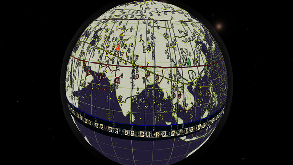
It now has a second way of existing. The whole chart has been reprojected, unwrapped along its vertical axis, and wrapped around the Earth with the Kunlun Mountains — Mount Kailash, the ancient Chinese centre of heaven and earth — at its heart. Stars and mansion lines sweep across continents and oceans and gather at the poles, until sky and earth coincide on a single sphere.
Four textures, four ways to look
- Star Map — the stele as it is: the circular all-sky chart sits beside the unwrapped star band, so you can follow the transition from carved disc to spherical strip.
- Star Map - Simple — stars, mansion lines and asterism labels only, on a fully transparent background. The band spans roughly twelve time zones and leaves the rest of the sky empty, so you can pin that one patch of heaven where you want it.
- Star Map - Full — the same star field stretched across all 360° of longitude, gathering at both poles. Transparent, so it wraps any planet without a seam.
- Star Map - Earth — the chart laid over an Earth with coastlines and a graticule. Land and sky at once: the closest of the four to the old idea of heaven and earth as one body.
What you can do with it
- Pick it straight from the texture browser and apply it to any planet — fully compatible with terrain, elevation and paint layers.
- Combine it with the paint and terrain tools to plot your own asterisms, routes and place names over the star field.
- Export projects or publish to the Steam Workshop: the texture travels with the save, so subscribers need nothing extra.
About those 1,434 stars
The chart was drawn by Huang Shang in 1190 as one of the "Eight Charts of the Shaoxi Era", presented to the crown prince Zhao Kuo (later Emperor Ningzong) as a prince's education in statecraft. In 1247 Wang Zhiyuan had it cut into stone and erected at the Suzhou Prefectural School; it was inscribed on China's first list of National Key Cultural Relics in 1961.
The stele is bluestone, 2.16 m tall, 1.08 m wide and 0.3 m thick. The chart is centred on the north celestial pole and bounded by three concentric circles — the circumpolar circle, the celestial equator and the circle of perpetual invisibility — plus the ecliptic, drawn with an obliquity of about 24° (the modern value is 23°26′). Twenty-eight radiating lines divide the lunar mansions, from Jing (34°) at its widest to Zi (1°) at its narrowest. Below the chart, some 2,100 characters of commentary gloss terms such as the celestial and terrestrial bodies, the ecliptic and the lunar path, the fixed and wandering stars, the Milky Way, and the twelve chronograms, stations and field allocations.
The star positions here are taken from the stele's chart and reprojected in equirectangular form so they wrap cleanly onto a sphere. Background and captions were reworked separately, so asterism labels stay legible at 8192×4096. "Simple" and "Full" share one set of star positions; the only difference is longitudinal coverage — about twelve time zones in the first, the whole 360° in the second.
Contents
- 4 star-chart textures at 8192×4096 (Star Map / Star Map - Simple / Star Map - Full / Star Map - Earth)
- Kept compatible with base-game updates — no reinstall needed
Note
Requires TerraNova Engine to use. This DLC contains texture assets only — no new terrain, planets or features.